Climate Hazard Exposure Assessment Methodology
Developed a standardized methodology for assessing asset exposure to climate hazards under both current conditions and future projections. The framework integrates local high-resolution datasets with global climate model outputs to enable consistent, scalable analysis across sectors.
Highlights
What the framework is designed to achieve and how it's structured.
Objective
- Create a repeatable framework for baseline and future hazard exposure assessments.
- Evaluate candidate datasets by resolution, reliability, coverage, and relevance.
- Enable consistent outputs for diverse asset types and sectors.
Method Overview
- Hazard selection for multi-hazard coverage: flood, rainfall extremes, landslide susceptibility.
- Dataset evaluation: local vs. global comparison, assumptions review, and coverage checks.
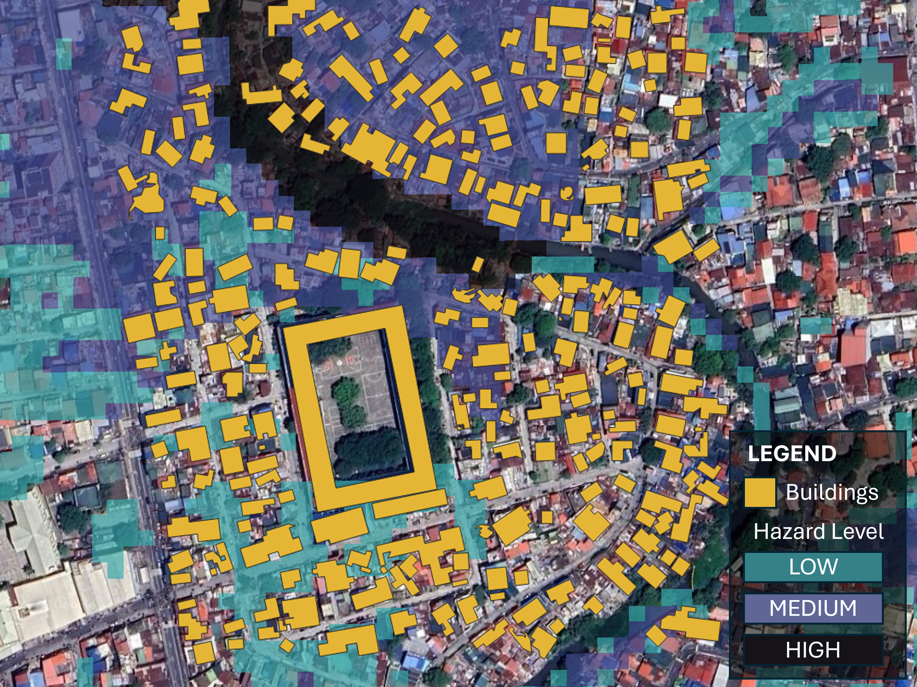
- Exposure extraction: overlay assets with hazard layers and summarize into interpretable metrics.
Tools
- Python (pandas, xarray, geopandas) for processing and automation.
- QGIS / ArcGIS for QA/QC, review, and cartographic outputs.
- Reporting outputs: maps, tables, and charts.
My Role
- Designed and standardized the methodology for repeatable delivery.
- Defined dataset selection criteria and documentation structure.
- Supported cross-sector applications with consistent output definitions.
Key Takeaways
- Combining local and global datasets improves spatial detail while maintaining future-scenario relevance.
- Documented selection criteria supports defensible and reproducible assessments.
- Standard outputs enable faster scaling across sectors and geographies.
Dataset Evaluation
Compare local and global hazard datasets to select best-fit inputs based on resolution, coverage, assumptions, and interpretability — and document decisions for defensibility.
- Assess spatial resolution, coverage, and temporal representativeness.
- Review metadata, underlying assumptions, and known limitations.
- Document selection rationale to ensure consistent and defensible assessments.
Illustrative Dataset Evaluation
Candidate datasets evaluated on spatial coverage, temporal scope, resolution, and accessibility to identify the most appropriate inputs for exposure assessment workflows.
| Criteria | Data Source 1 | Data Source 2 | Data Source 3 |
|---|---|---|---|
| Spatial Coverage | Global | Local | Regional + Global |
| Temporal Scope | Historical baseline | Historical baseline | Historical + Future projections |
| Resolution | Coarse (~10–25 km) | Fine (~5–30 m) | Moderate (~1 km) |
| Accessibility | Open source | Paid / licensed | Open source |
| Typical Use Case | Global risk screening | Local engineering analysis | Climate scenario assessment |
| Strengths | Consistent global coverage | High spatial detail | Future climate projections |
| Limitations | Low spatial resolution | Limited geographic coverage | Moderate spatial resolution |
Exposure Extraction
Overlay assets with hazard layers and summarize results into interpretable exposure metrics that are consistent and reusable across portfolios.
- Spatial overlays and buffer-based extraction as appropriate per hazard type.
- Summaries by counts, percentiles, and threshold exceedances — designed for decisions.
- Repeatable output format across asset types and sectors.
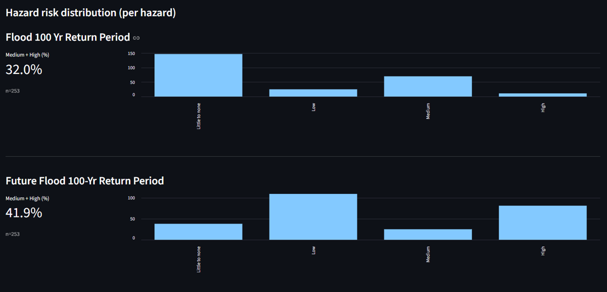
Scenario Comparison
Compare baseline and future scenarios — SSP/RCP-aligned pathways — to highlight shifts in hazard intensity and exposure relevant to planning and investment decisions.
- Baseline vs. future deltas summarized in a consistent, comparable format.
- Scenario framing supports risk prioritization and adaptation planning.
- Charts and tables designed for executive-ready reporting packs.
Data Privacy Note
This case study is generalized and displays only public, synthetic, or sanitized examples. No client-confidential information is included.